Never Get Lost On This Planet
The Bullet Points:
The AmbiCom GPS-USB is an inexpensive Global Positioning System (GPS) for Windows based PCs that uses the USB interface. It features 20 channel satellite navigation, SBAS/WAAS implementations, SiRF Star III, and supports NMEA-0183 protocol. (See explanation of alphabet soup elsewhere.) Its accuracy is within 5-10 meters of resolution, updating 10 times per second. Maximum altitude 59055 ft., maximum velocity 1690 ft./sec. (1,152 mph) It is 2.16” x 1.45” x 0.65”, weighs 2 oz. And has a 6.5 ft. USB cable. It works with Microsoft Streets and Trips 2006 and up, DeLorme Street Atlas 2006 and up, and most NMEA- 0183 compliant software. Works on Windows 98SE, 2000, XP and Vista.
What’s in the Box:
GPS-USB uni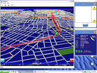 t, CD-ROM with drivers, Quick Installation guide.
The Review:
Curious about Global Positioning Systems (GPSs), but think they’re too expensive for a toy? The AmbiCom GPS-USB could be the answer to a question you don’t even have, and along the way, you may actually find it useful. At its nominal price of $45, it’s cheaper than an evening out, and the fun lasts a lot longer.
The GPS-USB is made by AmbiCom, who makes a wide variety of wireless and GPS devices adapted to everything from PCs to Palms and SmartPhones. The GPS-USB is dedicated to the PC architecture (logically a laptop) and is specifically made for Windows-based laptops.
I’ve had practical experience with GPSs for 20 years in aircraft, but I continue to be amazed at what silicon engineering has done to the interface and the price. The first civil aircraft units with moving map displays used to cost about $50,000, and had much less resolution than this $45 PC accessory.
GPS is a venerable technology: NAVSTAR-GPS was developed by DOD-ARPA in the late 1960s. It didn’t become available for civil use until the Korean Airline Flight 007 incident in 1983, at which time President Reagan issued a directive making the technology available free for civilian use in the interest of the common good. Early civil units had built-in offsets that limited their accuracy for military security reasons until after the fall of the Soviet Union. Present civilian units operate at the maximum resolution that the technology will allow. It’s an indication of how far the engineering has come to see how capable and inexpensive present units are.
Briefly, GPS works with 24 or so medium earth orbit satellites (non-geosynchronous) to trilaterate with each one it can receive, then combine this and do the math to convert this to latitude, longitude and elevation. When your receiver moves, it can track the movement and calculate your speed. In the case of this PC unit, the mapping application takes this raw information and converts it to some sort of display, depending on your mapping application.
Unlike hand-held units, the GPS-USB has no screen or buttons; it is software driven from your laptop, 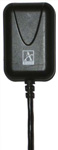 so you also need a mapping program that can communicate with the GPS. I used it with Microsoft Streets and Trips 2007 and Netropa iGuidance 4.0.
Let me be blunt - GPS on a laptop is not practical unless you are willing to spend a lot of time getting it going before using it. This is not a turn-on-ready-to-go setup. Starting from the ground up, you must start the computer, wait for a desktop, plug in the GPS, start the mapping software, wait for the application and wait for the GPS to wake up and synchronize to satellites. Cold-start wake up times for the GPS itself are up to a full minute before satellite signals are received and stabilized. So, don’t get in the car, then turn everything on and expect to go as soon as you start the engine. You also don’t want to start driving away before everything is ready because you are going to have to enter a destination address and respond to several Windows dialogs before GPS tracking starts working. If you think driving and dialing a mobile phone is dangerous, just imagine driving while typing and double-clicking. Your insurance company doesn’t cover this.
I’m not saying it’s useless, though. You simply must have enough time to set everything up before you get in the car and turn the key. If you ever take the time to go to the Internet and print a map before getting in the car, you can spend the same amount of time starting the laptop, the mapping program and GPS, then get in the car with it working. If you go to unfamiliar places a lot (I do), then you will find using the GPS and laptop less treacherous than trying to read a paper map while driving.
Mapping programs that use GPS generally give oral instructions while you are driving. This allows you to keep your eyes on the road. MS Streets & Trips give generic turn instructions in proximity without naming the exit or street. The iGuidance program is smart enough to actually call out the street name when you are approaching it, like a car-based GPS does. This is helpful when you are approaching an exit that leads to multiple streets.
The AmbiCom GPS-USB has a magnetic base for sticking it on the roof of a car or other vehicle, which should give better reception. 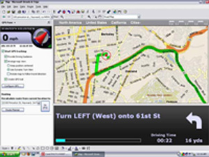
Streets & Trips screen. Red circle is present location. GPS traces route on map as you go.
Practically speaking, I found the receiver just as effective when placed on the dashboard under the windshield, which also avoids the nuisance of rolling down a window and placing it on the roof of the car.In use, the AmbiCom GPS-USB is very responsive and its accuracy is very impressive. If I drive into my driveway at home, the receiver knows I have strayed off the street and tells me that I am “off route”. The map zooms in and shows my path while I am walking to the front of the house and up the porch to the front door, then shows my path while walking into the house. Elsewhere, the receiver is accurate enough to see when I am driving on roads that have been changed during construction. In the case of MS Streets and Trips, the street data is more than a year old, and does not know, for example, that when I am driving over the new Benicia-Martinez bridge that I am indeed on a road: the program complains that I am “off route” and shows me merrily driving on water.
OK, so is this inexpensive GPS practical? Yes, if you are given to patience and planning. Frankly, a dedicated hand-held unit is more practical, simply because it’s easier to set up and use from the power button forward. If you need to use this technology a lot, you are much better off with a dedicated hand-held GPS. What the AmbiCom GPS-USB and its rivals offer is the ability to try out full-fledged GPS capabilities for less than the price of your average computer game. Some mapping programs, notably Microsoft offers Streets & Trips 2008 bundled with a USB GPS. It’s a practical way to find out if you need or want this technology. If you already have the mapping software, the cost of adding the GPS is trivial. Google Earth Pro (the pay version) will interface with GPSs, and this strikes me as one of the most appealing combinations possible because of Google Earth’s satellite imagery. Unfortunately, I can’t report on this as I don’t have the Pro version.
GPSs are the technical toy of the season. If you’re planning a driving trip this summer, get one and take it along: it’s cheaper than a tankful of gas, and might even save you some in lost driving. It will prove both entertaining and useful. Highly recommended
Product Information:
AmbiCom GPS-USB 2.x
Web Price $45
AmbiCom Inc.
405 River Oak Pkwy.
San Jose, CA 95134
408-321-0822
www.ambicom.com